|
CHAPTER 17 – THE HOLE THROUGH THE EARTH
 Dr. Frederick A. Cook is the most discredited explorer in all of Arctic
history. Cook was so thoroughly discredited that I never once thought of
even looking into the issues regarding his claim to have reached the North
Pole before Peary. It was only while paging through Wally Herbert’s “Noose
of Laurels” that I saw Cook’s map of his attempt on the
North Pole. Dr. Frederick A. Cook is the most discredited explorer in all of Arctic
history. Cook was so thoroughly discredited that I never once thought of
even looking into the issues regarding his claim to have reached the North
Pole before Peary. It was only while paging through Wally Herbert’s “Noose
of Laurels” that I saw Cook’s map of his attempt on the
North Pole.
As I
looked at this map I noted the proximity of two large pieces of land which
can no longer be found on any map: Crocker Land and Bradley Land. My
curiosity revolved around the proximity of these two pieces of land which
were independently ‘discovered’ by the most prominent polar explorers of the
time. Was this just an accident or was there more to this apparent
coincidence than met the eye?
(The author gives an extensive biography of Dr. Cook detailing the attempts
to discredit his claims to have climbed Mt. McKinley and to have been the
first to reach the North Pole. He describes the attacks on Cook’s character,
but also gives character references to show that Cook was not the type of
person his critics tried to portray him as. Besides being discredited, he
was imprisoned for mail fraud at Leavenworth Federal Penitentiary.)
Cook’s Human Relations
So far we have discussed Cook’s abilities as an explorer. But in pondering
his fights with Peary, it is worth considering him as a human-being. He was
trained as a medical doctor. What was his attitude towards his fellow
creatures? Was he the type of person disposed to lying and taking advantage
of them? Peary and his supporters have made the case for decades that
Cook
is a liar and a fraud. They portray him as a bumbling fool, intent on the
most childish sort of cheating. History portrays Cook as a con-man who
perpetrated one great fraud on the heels of another. Cook is depicted as a
man without standards, without any shame, without any decency whatsoever.
Is
this a correct assessment of him?
Prof. Ralph Myerson kindly sent me information regarding Dr. Cook’s
contributions to medicine. Cook was often brave and innovative. It is worth
considering his actions and some of his deeper thoughts. Here is some of
what Prof. Myerson sent:
“During the Belgian Antarctic Expedition,
Dr. Cook
made important innovations in the construction of tents, light-weight
sledges, protective clothing, and sun glasses. He was also instrumental in
freeing the ice-bound ‘Belgice’ by suggesting and supervising the
construction of channels in the ice leading to open water. Roald Amundsen,
the first mate aboard the ‘Belgica’, regarded Dr. Cook as his mentor and
developed a firm, life-long friendship that endured during Dr. Cook’s later
trials and tribulations. In 1901 Dr. Cook sailed to Belgium where he and the
rest of the ‘Bellgica’ officers received several awards including the
coveted Order of Leopold.”
“Later in 1901 he responded to a request from the
Peary Arctic Club to join
a relief party to Greenland and perform a physical examination on
Peary.
There was concern because Peary had been in the Arctic for four years and
hadn’t been heard from in two years. Although a rift had already developed
between the two men, Cook agreed and performed a remarkably thorough and
accurate examination on Peary at Etah. He is said to have made the diagnosis
of pernicious anemia, the ultimate cause of Peary’s death and recommended
that Peary eat a large amount liver. This was 20 years before Minot and
Murphy were awarded the Nobel Prize in medicine for recommending liver as a
treatment for pernicious anemia.”
“During his incarceration at
Leavenworth Federal Penitentiary, Dr. Cook
rendered valuable medical care to his fellow inmates, about a third of whom
were drug addicts… Cook wrote: ‘I was led to believe that modern
civilization is going under the cloud of a plague, more destructive in its
economic strain than that of all the wars in history. The opium blight, if
not checked, will eventually sap the life blood of half of mankind.’
Dr.
Cook developed a treatment plan for the addicts which was based on
non-specific supportive measures of water, exercise, sunlight and fresh
foods plus a program of lectures and assistance aimed at rehabilitation. It
may well have been one of the first such programs… Despite the controversy
that surrounded Cook during his later life, even his critics and detractors
are ready to recognize the above contributions made by him."
The Cook-Peary enmity contrasts strongly with the deep friendship which
existed between Cook and Amundsen. Amundsen even came to visit him in
prison. Amundsen was always a loyal friend and never forgot his mentor. That
someone of the caliber of Amundsen should remain friends with Cook through
thick and thin, to the bitter end, speaks volumes. If Cook was the bumbling
childish cheat which Peary’s supporters claime he was, then surely
Amundsen
would have seen this and agreed with it? Yet Amundsen always believed to the
end that Dr. Cook had indeed reached the North Pole first.
Amundsen once
remarked that Dr. Cook was: “The most extraordinary explorer I have ever
met.”
Did Cook Reach the North Pole?
A few years before Dr. Cook died he wrote the following:
“I have been
humiliated and seriously hurt. But that doesn’t matter any more. I’m getting
old, and what does matter to me is that I want you to believe that I told
the truth. I state emphatically that I, Frederick A. Cook, discovered the
North Pole.”
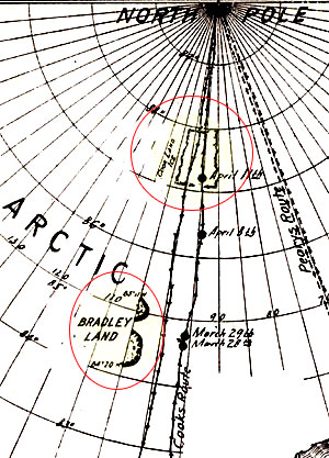
(In pondering what I had seen in Herbert’s book) I was stunned by the
realization that Cook had in fact been much closer to Crocker Land than
Peary had been. Not only that, but Cook had marked new islands on his map.
Stranger still, he had photographed Bradley Land! Cook later said that he
had looked for Crocker Land, but that it did not exist at the location given
by Peary. However, Cook had seen, photographed and pinpointed the location
of Bradley Land. Neither Crocker Land nor Bradley Land can be found on any
maps of the Arctic today. I posed this question to myself: Had
Peary, Cook
and MacMillan all told the truth back then?
Their testimonies are amazingly
consistent and definitely complimentary. In reviewing the evidence, I came
to the conclusion that the only instance of lying seems to me to have been
when Peary, with the connivance of MacMillan, set out to discredit
Dr.
Cook’s claims to the Pole. It is possible that both Cook and
Peary did
indeed reach the North Pole.
Having studied their accounts, I am of the firm opinion that there is
missing land up in that region of the Arctic. I further suggest that Bradley
Land may be distantly related to Crocker Land. The rediscovery of
Bradley
Land may go a long way to t racking the Crocker Land mirage back to its
roots. This should also lead us to finding out why these lands have been
kept secret for so long. I believe we will find that we have discovered a
Polar Hole.
Let us examine a detailed paper produced by Sheldon Shackelford Randolph
Cook, who is historian of the Cook Society. In March 1998 he produced a
paper entitled “Frederick Albert Cook, Discoverer of the North Pole. April
21, 1908 A Statement of the Evidence.” He wrote:
“Historically, the
strongest supporting evidence, the proof, t he final confirmation of an
explorer’s claim to discovery has lain in the verification of his
descriptions of the geographical area first seen, reached and traversed by
him by later exploration. If his first and original descriptions of this
region are confirmed and verified by later exploration, then his claim to
discovery is validated and established; if not, then his claim is disproved
or rendered questionable… Frederick Albert Cook’s first and original
descriptions of physical conditions and natural features at the North Pole
and in the region of the Central Arctic Basin through which he sledged have
been confirmed and substantiated by later exploration in detail after
detail,…”
Sheldon then provides supporting evidence on a point by point
basis.
The description above is critical when considering whether Cook was the
first to reach the North Pole. How could he have reported these conditions
if he had never been there? Remember, no one else had been there either and
conditions were different to what had been expected. Cook was unable to
return to Greenland before winter set in and he was forced to spend the
winter in Canada unable to reach his food caches. He and his Eskimos nearly
perished that winter. Nevertheless, with incredible courage and ingenuity he
survived. His attempt on the North Pole had thus taken much longer and been
far more dangerous than the conditions encountered by Peary. This makes
Cook’s assault on the Pole all the more amazing.
Renewed Support for Cook
(Statements of several people are given showing increasing acceptance of
Cook’s claims both to having climbed Mt. McKinley and been the first to
reach the North Pole.)
Bradley Land
That three different teams of explorers (led by Peary, Cook and
MacMillan)
should report land in virtually the same region seems to defy coincidence.
Ever since I looked at Herbert’s book “Noose of Laurels” I wondered if there
was a connection between Crocker Land and Bradley Land. Initially, I
wondered if Bradley Land was an outlying island not far from the continental
land mass of Crocker Land.
I have also wondered if Bradley Land and
Crocker
Land might perhaps be one and the same. (Much discussions follows concerning
the reality of Crocker Land and Bradley Land and of the authenticity and
implications of the photograph which Dr. Cook took of Bradley Land.
Statements are given as to whether the photo was taken in the location
claimed and whether it depicts actual land or an ice island. Problems of
distances and shapes are also analyzed.)
The Bradley Land photograph contrasts strongly with another feature which
Dr. Cook called the ‘submerged island’. This is glacial ice floating on the
sea very close to the North Pole. Photographs of the ‘submerged island’ and
Bradley Land exist and they are two very different features. The
Bradley
Land photograph shows hills of considerable size whereas the ‘submerged
island’ is nothing more than glacial ice at sea-level. Dr. Cook thought this
ice was resting on a submerged piece of land, hence he called it the
‘submerged island’.
Just when you thought there could not be any more twists to the story, let
me add one more. Wally Herbert uses the ‘fact’ that there is no land up in
the Arctic as the cornerstone for his arguments against Dr. Cook. In his
book he has a photograph of the ‘submerged island’ of glacial ice at
sea-level. He then goes on to claim that Dr. Cook did not print the entire
plate in his book. He claims that when this original plate is reproduced
fully, one then sees a chunk of land on the right-hand side. He reproduces
this fuller version of the photograph in his book.
Herbert then states that
this clearly shows the ‘submerged island’ to be a glacier resting on dry
land! In this version of the photograph one can indeed see an enormous piece
of dark rock which is many times taller than Cook’s companions. Judging by
the slope of the rock, it seems as if this is the edge of a much higher hill
of great size. Since there is no land close to the North Pole, Herbert then
claims that Dr. Cook was a liar. But wait.
Dr. Cook said the ‘submerged
island’ was ice which rested on submerged land a mere 120 miles from the
North Pole. Could it be that there really is some rock jutting out above
sea-level there? Could this be part of a shallow continental shelf related
to land which really exists some distance away? To tell the truth, I don’t
really believe this myself. I think something funny is going on. The piece
of rock in that photograph is very large – perhaps 30 ft high, maybe more.
It’s very hard to tell. But it is very large and must weigh many tons. It
appears to be part of a much larger feature.
I find it inconceivable that
Dr. Cook would spend so much time talking about glacial ice when he could
have marked this piece of land on his map as well. His sledges were a few
hundred meters away from it, and he could have walked upon it. His testimony
contradicts what is in this ‘full’ photograph. He referred to the ‘submerged
island’ – believing that the glacial ice rested on land beneath sea-level.
Now if some land actually stood out, he would surely have drawn attention to
it, especially if it was this large. But he did not. He did not remark upon
the northernmost island on the face of the Earth. Strange.
I am suspicious of this photograph. Wally Herbert claims he found this
photograph in the Library of Congress collection of Dr. Cook’s material. As
will be seen later, Herbert also discovered that key photographic plates
were missing from the Cook collection. Who took them? Dr. Cook’s photograph
of Bradley Land was missing, as well as the photograph taken at the North
Pole. Could it be that the US government itself has been fiddling with Dr.
Cook’s polar material in the Library of Congress? I am highly suspicious of
this piece of rock in the ‘full’ ‘submerged island’ photograph.
Could it be
that this photograph has itself been manipulated by someone in a
sophisticated attempt at further discrediting Dr. Cook? If there really had
been land at that latitude, then why did Dr. Cook not mention it? We could
always fall back on the ‘fake photo’ theory, but to do so would be to ignore
the much greater evidence to the contrary. Is it possible that someone could
actually produce a faked plate and place it in the Library of Congress,
while removing the original? Who on Earth would have the scientific
capability to produce a specially manipulated plate like this?
Unless
someone in the US government and US military has gone to great lengths to
attempt to discredit Dr. Cook – in an attempt to hide Bradley Land and the
drifting glacial ice of questionable origin. These people may feel it better
to encourage researchers to look towards Axel Heiberg Island where these
photographs were supposedly faked than to have potential explorers flying
and traversing the Arctic Ocean where Crocker Land and Bradley Land might
exist.
It is strange that the Cook Society puts itself squarely behind
Dr. Cook and
then suddenly makes an about turn on the above point refusing to accept his
estimates and conclusions regarding Bradley Land. If he was the competent
explorer they claim him to be, then why are they abandoning him on this
point? The photograph of Bradley Land poses serious problems for the
Cook
Society. Much as they would like to believe him, they are faced with the
‘fact’ that land does not exist at the location given. This puts
Sheldon
Cook in a tough spot and he clearly recognizes that he might be faced with a
losing battle. So he tries to hedge his bets both ways:
“If glaciologists
should eventually determine that the photograph of Bradley Land in
Cook’s
book in fact depicts ice-sheathed land rather than an ice island, it must be
concluded that Cook simply used a photograph of a feature which as nearly as
possible approximated what he had seen west of his line of march for the
purpose of illustrating his book…”
I think Sheldon is undermining his entire position by proposing that
Dr.
Cook started taking photographs to ‘represent’ things he had really seen. I
know of no rule of exploration which allows one to do this. If Cook ever did
this, then the onus would have been on him to state so openly in his book.
He claimed these things were fact and stood by his claims until he died.
Bradley Land and the submerged island are the two most important physical
features he saw during his assault on the North Pole.
For key
Cook
supporters to begin using this type of logic is highly dangerous. If Cook
used photographs to represent physical features, how can we then trust his
photographs taken at the North Pole? Sheldon is opening up a Pandora’s box
filled with problems for Dr. Cook by following this line of reasoning. In a
sense, his reasoning leads almost to a direct admission that Dr. Cook was
making things up as he went along.
And yet, there is so much evidence to the
contrary. As Sheldon acknowledges, making up evidence is a highly dangerous
undertaking because other explorers will be checking up on it. For example,
Cook’s photographs show the enormous hills of Bradley Land. Now what if
someone were to go there and find a different configuration? What then? Such
things would not go unnoticed, and Dr. Cook would be called upon to explain
this discrepancy. In fact, one of the ‘rules’ of exploration is that later
explorers must check upon and confirm the discoveries of those who went
before. Photographs, maps and written descriptions are therefore taken very
seriously by geographers and later explorers.
The photograph (Plate 31 in the book) may provide us with the answer to the
problem. Take a look at the hills shown in this photograph. The hills cover
most of the horizon, except for a region in line with the first sledge. At
this point there appears to be a gap in the line of hills. When Dr. Cook
plotted the coastline of Bradley Land, he drew it as two separate, distinct
pieces of land, separated by a gap of several miles. That gap seems to be
evident right there in that very photograph. Would you have me believe that
he went looking for a feature of the right size, with just such a gap,
elsewhere, for photographic purposes? Why should this photograph seem to
reflect, exactly, the facts as he plotted them on a map?
Wally Herbert mentions another interesting point:
“The search for ‘Bradley
Land’ is made even harder since the only picture available is the one in his
book, the original plate is missing from the Cook Collection in the
Library
of Congress, as are also the plates of the two other crucial pictures: those
of his ‘North Pole’ camp and his ‘summit picture’ of
Mt. McKinley.”
I find
it very interesting that all the original plates in support of Dr. Cook’s
claims are now missing. All we have left are the photographs which are in
his books. Now why would all these originals ‘go missing’? Or has someone
deliberately removed them to undermine Dr. Cook’s position? Did
Peary’s
supporters remove these photographs? Or did military officials go to the Library of Congress to remove these originals at a later date? Or was this
sanctions by the US Government itself?
What do we make of the ‘full’ ‘submerged island’ photograph? Why did
Dr.
Cook not reproduce this? Or was this plate produced and placed in the
Library of Congress in recent years by a US Government which is intent on
hiding something in the Arctic? From day one, the US Military had it in for
Dr. Cook. Peary, MacMillan and all their military supporters set out to
destroy Dr. Cook. Did they do this merely from jealousy or were they, back
then, already aware that something untoward might exist in the Arctic?
There
was much Hollow Earth discussion going on in the decades prior to the
discovery of the North Pole. Were the US Government and the US Military back
then already interested in the subject? For more than a century prior to the
discovery of the North Pole, there had indeed been much said and written
about a possible entrance into an Inner World via a hole in the Arctic. Many
people had attempted to bring this to the attention of various governments,
especially the US Government.
These governments never put much stock in
these bizarre theories. However, they must certainly have been aware of
these ideas. I follows therefore, that if any credible evidence were to
later surface, these governments might very quickly have realized the true
significance of what was going on and taken action immediately. The issues
regarding Crocker Land and Bradley Land at first might not have meant much
to anybody.
Peary and MacMillan were probably motivated by jealousy alone
and nothing more. However, much later, perhaps during the Cold War, the true
importance of these discoveries might have become apparent. This may have
required that further action be taken to ensure that no one ever looks
seriously into these issues. This might explain the strange happenings to
Dr. Cook’s material in the Library of Congress. It might have required that
a more subtle and sophisticated attempt be made to ensure that Dr. Cook
remained discredited for the time being – perhaps while the governments
concerned try to find out what is really going on inside the Earth.
What conclusion can we draw regarding Dr. Cook’s journey to the North Pole?
(The author reviews and speculates on the information recorded by Cook, Peary, and MacMillan concerning Crocker Land and Bradley Land.) Remember
that Peary and MacMillan saw Crocker Land to the
North West? And Cook saw
Bradley Land due West. If one draws their line-of-sight on a map it then
results in these lines meeting at a single spot some distance west of both
Crocker Land and Bradley Land. Is this where Crocker Land and Bradley Land
physically exist. Maybe. The thought that Crocker Land and Bradley Land may
be one and the same, and that they lie further west of their supposed
positions is tantalizing. This could explain why Bradley Land has also not
been found yet – at least by civilian explorers. Perhaps the key to the
whole problem is to travel further west of the positions given for these
lands?
The Map Evidence
While I was looking for old maps, Billy Baty happened upon an old map in a
text book. Unfortunately we could not discover the origins of this map.
Nevertheless, it had some interesting notation on it. Up in the region
directly north of the Bering Strait, but falling short of the North Pole, it
had the notation “This sea is probably never completely closed”. This
notation was in the region where Lt. DeLong would have expected to find his
Polar continent. One can’t help wondering what caused the map-maker to reach
this conclusion, but it has overtones of the Open Polar sea.
Let us also hark back to earlier chapters such as the one on meteorology. In
the chapter it will be remembered we discussed the origin of strange clouds
which seemed to somehow be related to the Earth’s magnetic poles. The
direction in which these clouds moved, depending from where they were
spotted, seemed to suggest that they originated from the Earth’s magnetic or
geomagnetic poles. These same clouds, when seen from the USA, did not seem
to have that orientation. This is understandable if their real point of
origin lay somewhere between the North Magnetic and the Geomagnetic North
Poles.
Crocker Land and Bradley Land lie at a spot equidistant – almost –
from these points as well. Could it be that these lands lie near a Polar
Hole? If so, could it be that these strange clouds really originate from a
point close to Crocker Land and Bradley Land and that depending on one’s
longitude, one would mistakenly think these clouds are aligned with the
magnetic poles?

The Reader has probably wondered about the relationship between a Polar Hole
and the Earth’s magnetic field. Should a Polar Hole not coincide with either
the North Magnetic Pole or the Geomagnetic Pole? This is a question which I
have wondered about many times myself. Strictly speaking, if the Earth’s
magnetic field originates from inside the Earth, then the magnetic lines of
force should direct us straight to a Polar Hole. By this definition one
should find a Polar Hole exactly at the Geomagnetic Pole. The Geomagnetic
Pole lies between Canada and Greenland.
The aurora and the Earth’s entire
magnetic field are centered upon this point, and this is the logical place
where one should find a Polar Hole. The North Magnetic Pole lies closer to
the Beaufort Sea – and it moves considerably. The Russians believed for a
long time that another magnetic pole lay in Siberia as well, and that
magnetic lines of force bunched together across the Arctic between the
Siberian and Canadian Magnetic Poles. These lines of force come very close
to mystery sediments which lie very close to Bradley Land and
Crocker Land.
Larry Newitt, the Canadian scientist who has determined the position of the
North Magnetic Pole in the Queen Elizabeth Islands near the
Beaufort Sea,
told me that the Russians later dropped their theory of the Russian/Siberian
Magnetic Pole. He stated that they believed in it right up to the 1980s.
As was mentioned earlier, since the Earth’s crust is essentially rigid, it
is highly likely that large quantities of ore are down there. This ore very
probably distorts the Earth’s magnetic field thereby creating a situation
where the North Magnetic Pole is a considerable distance from the
Geomagnetic Pole. Strictly speaking, the North Magnetic Pole should also be
at the Geomagnetic Pole. And both of them should actually be at the
North
Pole because that is the axis about which the Earth spins. The mere fact
that the North Magnetic Pole lies a considerable distance from the
Geomagnetic Pole is itself anomalous. This clearly indicates that a
considerable distortion of the Earth’s magnetic field occurs near the
surface. This being the case, it is to be expected that the geomagnetic
field is so distorted that the Geomagnetic Pole does not coincide with
position of a Polar Hole.
However, a Polar Hole cannot lie too far away from
the Geomagnetic Pole. I drew a triangle between the Geomagnetic Pole, the
North Magnetic Pole, and the site of the ‘Russian Magnetic Pole’. One would
expect a Polar Hole to lie either within, or close to this triangle. The
evidence suggest to me that the line connecting the North Magnetic Pole and
the ‘Russian Magnetic Pole’ is the place to start looking. In Figure 17.2 we
see Keenan Land marked near the coast of Alaska. Note too, the Eskimo
sightings of land from Camden and Harrison Bays in Alaska. Could it be that
these Eskimos were really seeing a ‘telescopic’ mirage of land which lies
much further north? Could Capt. Keenan’s sighting of land actually be a
sighting of that same land? Perhaps. If so, the suggestion is that land must
lie somewhere up in the Beaufort Sea. And what of the Eskimos who actually
traveled to this land and found other Eskimos living there?
My information regarding Sannikov Land is scant. I had wondered if
Sannikov
Land might simply be the Crocker Land mirage seen from the other side of the
Earth. However, that does not seem to be the case because the Russians saw
it to the north and north-west. Sannikov Land might be a problem similar to
Bradley Land, but from the Russian point of view. Sannikov Land might simply
be land lying in the far north, not far from a Polar Hole. Its existence
might be covered up for the same reasons that Bradley Land’s existence is
denied. It might simply be too close to a Polar Hole for comfort to allow
civilians to wander in its vicinity.
When all these sightings of land and the meteorology are taken into
consideration, we find ourselves contemplating the existence of land and a
possible Polar Hole somewhere due north, or slightly NNE of Alaska, falling
short of the North Pole by approximately 5 degrees. Many people will of
course say this is totally impossible. What of those, such as Wally Herbert,
who traveled up there in the 1960s? This make me wonder. I have pondered
Wally Herbert’s motives for doing such a nasty hatchet job on both
Dr. Cook
and Peary. Could it be that some of these expeditions across the Arctic have
been staged so as to make us think people have been in a certain region when
in fact they have not?
Wally Herbert was well aware of the slow speed at
which his expedition traveled. This has subsequently been highlighted by
comparisons with Peary and with Will Steger’s 1986 expedition.
Herbert
accounted for this by saying that he had to make a considerable number of
detours around pressure ridges with his heavy sledges. Really? Or was
Herbert making a detour around something else? A Polar Hole maybe? One
should not exclude the possibility of sophisticated deception. If something
is of critical importance, then clever people, in positions of power, might
well go to great lengths to cloud the issues to ensure that these things are
not discovered by accident. These are probably patriotic people who are
convinced of the correctness of their actions.
Could Wally Herbert’s vicious attacks on Dr. Cook and Peary have the deeper
motives of discrediting their testimony of Crocker Land and Bradley Land?
Consider his theory that Peary lied about Crocker Land simply to ensure that
he could raise money for future expeditions of his own. MacMillan’s
first-hand testimony of Crocker Land makes nonsense of that idea.
Scientists, to this day, recognize that something is not quite right with
the problem of Crocker Land, and no one has come up with a truly
satisfactory explanation for it. Since Cook had been thoroughly discredited,
the possible existence of Bradley Land was never taken seriously. But, even
the Bradley Land mystery is slowly coming to the fore again as people take a
renewed interest in Dr. Cook.
There is visual evidence which suggests that a certain region of the
Arctic,
slightly off-set from the North Pole (by about 5 degrees) is open to
suspicion. Strange, off-beat things have been seen here by famous explorers.
None of these things, including the strange meteorology we have discussed,
seem to make much sense within the bounds of our science. So far we have
only concentrated on Cook, Peary and MacMillan. But, has anyone else seen
any indication of land up in this part of the Arctic? Take a look at this
introductory e-mail which I received from Prof. Myerson on 17 June 1998:
“Allow me to introduce myself as
Ralph Myerson, MD, Vice-President of the
Frederick A. Cook Society. Russ Gibbons has furnished me with a copy of your
correspondence… I have no expertise in your research; my interest lies
mainly in the area of Dr. Cook’s medical talents and the many
incontrovertible contributions he made to polar medicine. I do recall,
however, that when Amundsen visited Cook when the latter was serving time in
Leavenworth Federal prison (another sad story of a travesty of justice), he
(Amundsen) expressed some belief in the existence of Bradley Land and stated
that when he flew over the area of its location, he saw land birds in the
region, too far for them to have come from the Canadian archipelago.”
Soil From Inside the Earth?
Consider the following scientific evidence from the magazine “Discovery”:
“How did sand and gravel, typical of sea-shores and river beds respectively,
reach the deep ocean bottom of the Arctic hundreds of miles from the nearest
land? This has been the puzzle facing the American researchers who have been
analyzing ocean-bottom samples dredged up in the Central Arctic Basin not
far from the North Pole from the IGY drifting station Alpha, a temporarily
occupied ice floe which circulated in the region between 84 and 85 degrees
N, 138 to 152 degrees W during eighteen months of 1957-58.”
The article in
“Discovery” went on to say that this analysis was the most comprehensive
ever undertaken in this ‘inaccessible region’ of the Arctic. The scientists
thought the mysterious sand and gravel were a ‘most remarkable feature’ of
this part of the Arctic Ocean. They wanted to know where these sands and
gravels originated from. They concluded that the sand was not carried there
by water because the particles showed very little ‘rounding’. Experience had
shown that even a journey of less than 500 meters through water increases
the roundness of particles by several factors.
Yet, the gravel must have
traveled several hundred kilometers at the very least, in a straight line,
to have originated from one of the existing landmasses. Considering that the
water in the Arctic Ocean travels in a circular fashion, this translates
into a journey of at least ‘thousands of kilometers’. The scientists went on
to suggest that the soil got there by ‘ice rafting’. The problem with this
suggestion is that there would have to be ocean currents capable of
transporting large quantities of sand and gravel towards the North Pole. But
from which rivers did these sands and gravels originate?
Let us take a closer look at the transport problem. Firstly, there are no
currents which flow directly towards this spot. The entire ocean in this
region tends to flow in a circular fashion. At first glance the Reader might
think that these sands and gravels originated from the Canadian Islands.
However, the problem here is that there are no rivers on these frozen
islands of the far north. The most likely rivers which could have provided
the gravel are actually in Alaska.
But for the soil to have been transported
from Alaska (or even
Canada) would require it to travel a considerable distance along a circular
route out into the Arctic Ocean. Unless the soil was transported on top of
the ice, the soil would have been rounded by traveling through water. Life
in the distant Arctic seems almost impossible to consider. And yet, the
sub-Arctic, in Canada for example, is much colder than it is out there in
the middle of the Arctic Ocean. Do these sediments originate from Crocker
Land or Bradley Land? Do rivers flow there? Are there perhaps hot springs up
there which make the climate milder thereby enabling some Eskimos, birds and
other animals to live up there?
Winds From Nowhere
Dr. Cook mentioned the considerable haze which was present during his trip
to the North Pole. He described it as a bluish haze. Consider the following
strange information from “Mosaic” in 1978.
Every year, in March and April, a strange haze descends upon the clear
pristine air of Alaska. This haze lies at an altitude of 10,000 ft and gives
the sky a whitish, diffuse look. When seen from an airplane, it causes the
horizon to disappear completely. Scientist studied the haze to try to
determine its origin. They discover it was largely made up of:
(a) Dust
(b)
Sulphuric acid droplets
Scientists concluded that the dust and sulphuric
acid,
“… must be imported because there are no sources of such materials in
the Arctic.”
They theorized that violent wind storms in the Gobi Desert
might be responsible for the dust. However, the sulphuric acid was a greater
mystery. They speculated that perhaps the sulphuric acid droplets were
produced by Japanese factories and that it was then carried to Alaska by
strong winds. However, they were not sure if this was really the correct
answer. They concluded that:
“These are speculation, though, and no one is
sure where this haze comes from or how far it extends beyond Alaska into the
stable, stagnant air over the Arctic Ocean.”
Do you remember the presence of sulphuric acid droplets in large quantities
in the polar atmosphere of Venus? Could there be a link between such
sulphuric acid mist and the Inner Earth? “Mosaic” stated that the haze
actually extends far out into the Arctic, north of Alaska. Does this haze
really come from Japan? Japan lies south west of Alaska. We know from Dr.
Cook that a haze did indeed extend all the way up to the North Pole. Does
this haze originate from somewhere near the North Pole? To the best of
my
knowledge, Peary never mentioned this haze while on his journey to the North
Pole.
Could it be that this haze emanates from the region where Crocker Land
and Bradley Land exist? Is there a link between this strange haze and
Goesta
Wollin’s discoveries, and the other strange meteorological phenomena
mentioned in earlier chapters? Does this haze provide a natural camouflage
for Bradley Land and Crocker Land, making their discovery very difficult?
Could this haze and mist be related to large numbers of hot springs on an
unknown landmass in the Arctic?
Polar Holes
I just cannot see how a sizable piece of land up in the Arctic could have
remained undiscovered to this day. I have thus speculated on whether some of
this land really belongs to the outer surface of our world as we know it, or
whether it lies inside a Polar Hole of some kind. And how big could such a
hole be? When I originally began this study, I had been driven by the idea
of a tiny Polar Hole – perhaps as small as 50 miles across. But as I reach
the conclusion of this study, I can’t help wondering if it’s much larger –
perhaps 100 or 200 miles across. It still falls considerably short of the
figure proposed by Marshall Gardner and others, of a hole 1,400 miles
across.
Nevertheless, it could be hundreds of miles across. Such a feature
would definitely have some effect on our weather and would help to explain
some of the strange meteorological phenomena noticed by scientists. The
eye-witness accounts of missing lands and continents of considerable size in
the Arctic leave me wondering about the size of a Polar Hole and any land in
or around it. It seems as if we are dealing with a landmass which is very
large. It may be that the accompanying Polar Hole is also quite large.
The mirage theory seems to work quite well as an explanation for the strange
mirage called Crocker Land. But the same does not quite seem to be true of
Bradley Land. Does Crocker Land therefore technically belong to the
Inner
Earth while Bradley Land is some kind of outlier which belongs to the outer
surface? Perhaps. If so, then why is Bradley Land not on any map?
Could it
be because it lies near a Polar Hole?
But is there any other way of determining whether there is a hole right
through the Earth? In an earlier chapter I speculated about the rising and
falling atmosphere of the Earth. I have wondered whether some scientists
have perhaps already discovered a hole through the Earth without realizing
it. In the early 1980s, while browsing through the Pretoria Public Library,
I came upon a book which discussed the effects of a nuclear war. It was a
well-researched book, and I read it. Since the major powers of the world are
located in the northern hemisphere, and since a nuclear exchange is more
likely to place in the northern hemisphere, the author made a point which
surprised me.
Scientists had concluded that very little radioactive fallout
from the northern hemisphere would reach the southern hemisphere. The
accuracy of this statement has been confirmed by other people who are
knowledgeable in this field. Meteorology teaches us that winds tend to blow
from the equator to the poles and back. Hence radioactive material blowing
from the north towards the equator is very likely to be caught up by poleward winds and circulated back to the north. This will happen before the
radioactive fallout manages to cross the equator into the southern
hemisphere. The same is true for air moving from the South Pole to the
equator - the air will be circulated back to the south.
On 26 April 1986 the worst peace-time accident to date occurred. Fires and
explosions were caused by an unauthorized experiment at the Chernobyl
nuclear plant in Russia. Thirty-one people died in the immediate aftermath
and 135,000 were evacuated from areas around Chernobyl. Some areas were
rendered uninhabitable and significant quantities of nuclear material were
spread around Europe by the prevailing winds. Being aware of the virtual
impossibility of nuclear fallout reaching the southern hemisphere, you can
imagine my surprise on learning that scientists suddenly discovered
radioactive fallout from Chernobyl – at the South Pole.
This was reported in
“Science News” in May 1990. Jack E. Dibb, a geochemist from the University
of New Hampshire, collected samples from a snow pit about 38 Km from the
South Pole. In the deeper portion of the pit he and his colleagues found
radioactive layers corresponding to the years 1955 – 1974. Above ground
nuclear testing was at its peak during those years.
They also found a
radiation ‘spike’ which was approximately 20 – 30 times greater than the
normal background radiation levels. They found this ‘spike’ in the snow
deposited near the top of the pit. This snow had fallen some time between
late 1987 and early 1988. More specifically, they found that the
radioactivity came from caesium-137 which does not occur naturally.
Caesium-137 only comes from nuclear reactors or
nuclear explosions.
Scientists have discovered that it takes approximately 20 months for
radioactive fallout from nuclear test in the northern hemisphere to reach
the South Pole. The radioactive deposits from Chernobyl also took 20 months
to reach the South Pole.
Based on the discoveries of Jack Dibb et al, we can
be absolutely certain that the radioactive fallout from nuclear tests and
nuclear accidents in the northern hemisphere are indeed reaching the South
Pole. But how? In a letter to “Nature”, dated 3 May,
Dibb’s team proposed
that the radioactive material rose high into the stratosphere, crossed the
equator and then fell in central Antarctica. As can be appreciated,
atmospheric scientists, who know how winds behave, were very skeptical of
this explanation. These atmospheric scientists doubted whether significant
amounts of Chernobyl fallout could ever cross the equator and be deposited
at the South Pole.
The problem becomes even more mysterious because it turns out that there is
no evidence whatsoever that the radioactive material ever crossed the
equator to begin with. Radioactive material would have been detected at
various places en route to the South Pole, and in other parts of Antarctica.
But there was none. Furthermore, as the radioactive material continued its
journey, there would have been less and less of it as it approached the
South Pole. Instead, it turns out that there is a high concentration of this
material at this one spot in Antarctica. Dibb tried to explain it by way of
“… special wind patterns above the
Antarctic might explain why the South
Pole is the only spot in the southern hemisphere where scientists have
detected excess caesium-137 following the Chernobyl event.”
The mystery
grows. But the atmospheric scientists disputed Dibb’s explanation. It’s one
thing dealing with above-ground nuclear tests where perhaps some of the
fallout did rise high into the sky and some of it did perhaps manage to get
across the equator. But, they point out that none of this is true for
Chernobyl. The radioactivity from Chernobyl never reached high altitudes as
happens with the super-heated air in an atomic explosion.
The Chernobyl
material lay at a much lower level in the atmosphere. So how could it get
from latitude 51 degrees N in Russia to the other side of the Earth? Jerry Malman from the
Geophysical Fluid Dynamics Laboratory at Princeton also
disputed Dibb’s explanation. He maintained that water condensation in the
rising air would have washed the caesium out. He could not conceive how any
significant amount of matter could have crossed the equator. Malman’s
criticism is very valid, especially with respect to the humid air found at
the equator.
So the mystery remains. How did low lying radioactive air from Chernobyl in
Russia end up in a single spot at the other end of the Earth, along with
other high-level radioactivity? Let’s go back to Lt. Col. William E. Molett
who told me that he had flown more often to the North Pole than anyone else.
Lt. Col. Molett was the navigator on board of the modified bombers which
were sent by the USAF in the 1950s to collect radioactive fallout at the
North Pole. Molett flew 91 classified missions to the North Pole. Molett
told me telephonically that the purpose of the missions at the time was to
obtain air samples from the air above the North Pole. Why?
Because the
radioactive fallout from Russian nuclear tests were blown northwards and
were concentrated at the North Pole by natural wind patterns. Over a period
of almost five years, Molett continued with these regular flights to obtain
air samples from the North Pole. These would be analyzed by American
scientists to determine if the Russians had been conducting secret nuclear
tests.
We now know that air currents will concentrate radioactive fallout in and
around the North Pole. The conclusions of the atmospheric scientists who
disputed Dibb’s theory are therefore well-founded. So how then does this
concentration reach the South Pole? Many Russian nuclear tests are conducted
far north. I stand to be corrected, but I think the Russians conduct some
nuclear tests on the Kola Peninsula which lies at the northernmost point in
Russia. I am not sure if they ever conduct above-ground nuclear tests there.
What if there is a hole which goes all the way through the Earth? That is an
option which scientists have obviously not considered. What if air sometimes
gets sucked into this hole and is sometimes blown out of it due to changing
air pressures and the changing seasons on the outside of the Earth? The
atmospheric conditions inside a Hollow Planet, regardless of what they are,
should be relatively stagnant compared to the outer surface.
Any Inner Sun
which may be there will remain relatively fixed in position and the surface
will suffer from the same level of heat or cold, light or darkness
throughout. Hence, there is no reason why atmospheric pressure inside a
Hollow Planet should change much except when the Inner Sun itself becomes
more active. The major meteorological driving force must therefore lie on
the outside of the planet. It is the changing angle of the Earth with
respect to the Sun which determines the seasons on the outside of the Earth.
When it is winter at the North Pole, it is summer at the South Pole. I seems
probably to me that when air is being sucked in through one Polar Hole, it
must be blown out of the other.
This does of course imply that there must be
a slight interchange of hemispheric air at the equator to balance this
scenario. It follows that some air may be sucked in one Polar Hole, and over
time it might end up being blown out of the other. As an aside, let me add
that the atmosphere inside the Earth might be modified slightly by the
conditions which are present there. Various chemical and other changes might
be made to it while inside the Earth. A scientific study of air entering and
leaving the Polar Holes might therefore teach us something about conditions
inside the Earth.
Let us return to the Chernobyl problem. If a Polar Hole is located near the
North Pole, it then follow that it would suck in the air with the greatest
concentration of radioactivity in all of the northern hemisphere. On time
some of this air would travel right through the Earth and end up being
deposited somewhere near the South Pole. We can therefore infer that the
entrances to this hole through the Earth lie somewhere near, but no exactly
at, the North and South Poles. There are of course no Polar Holes marked on
any maps, but one could consider trying to find them by way of weather
balloon experiments.
If one has the patience, one could try seeing if
weather balloons can be sucked into the Earth at one Pole and then spewed
out 20 months later at the other Pole. By tracking these balloons, one could
establish with absolute certainty whether they traveled along the outside of
the Earth or whether they entered the Earth. By noting the points at which
they disappeared and reappeared one could then determine exactly where these
Polar Holes are. The mere fact that the low-level Chernobyl radioactive
fallout was concentrated in a small area near the South Pole is, to me,
highly suggestive of the existence of a South Polar Hole not far away.
We can do one better than merely guessing at the existence of Polar Holes.
We can try to find them. In my research I tried to see if I could narrow
down the possible location of a North Polar Hole. The Antarctic has a small
population of only 3,000 people and information about it is more scant than
for the Arctic. I therefore concentrated my efforts on the
Arctic because
the chances of success seemed higher. It is also far easier and cheaper to
travel into the Arctic to find such a thing. The Arctic has been more
thoroughly traveled and studied than the Antarctic. Consequently, there is
more data to go on. It is also highly probably, if not a virtual certainty,
that the North Polar Hole was discovered first, and therefore one might pick
up clues from Arctic exploration since the original discovery would have
happened unexpectedly. Hence my interest in Crocker Land and
Bradley Land
and in the early, uncensored testimony of Arctic explorers.
Conclusion
This effectively brings to a close my years of incessant research into the
matter of Hollow Planets. It is now four and a half years since the issue
was first raised, and I look forward to some rest from this obsession of
mine. You can take a look at any map in any atlas, in any country. Look in
the vicinity of Crocker Land and Bradley Land and you will find nothing by
ocean. The seafloor in these regions has supposedly been mapped too. There
is nothing you will find in any literature in geography to indicate the
existence of land at these points, or to suggest the existence of Polar
Holes anywhere.
In testing this centuries-old idea, I set out to find a hole which might
lead into the Earth. There is no scientifically accepted evidence that
planets are hollow. It is a taboo subject which only crackpots like myself
can entertain. But what if it’s true? What if Dr. Cook and Commander Peary,
in their attempts to reach the North Pole, stumbled upon the outskirts of a
vast land sitting up in the Arctic, near/in a Polar Hole? What if the full
extent of the problem only became clear to the governments of Russia,
Canada, and the USA when the Cold War started after World War II? What if,
at the height of the Cold War (when military secrecy was at its greatest) it
was discovered that the Earth was hollow?
What of MacMillan’s conclusions that Crocker Land was a mirage? The science
of optics has come a long way, and what MacMillan saw could only have been
based on something else. Peary saw Crocker Land from two different angles
days apart. MacMillan, Green and the others saw it at least three times
through field-glasses and even with the naked-eye, close-up. Peary said it
was enormous. MacMillan did too. Then we have Dr. Cook’s strange photograph
of Bradley Land. Amundsen’s tale of the land birds flying towards
Bradley
Land, and Wilkins’ altimeter story. Is Bradley Land real as well? And what
of Capt. Keenan, and the Alaskan Eskimos and the land which lies north of
Alaska? What of Sannikov Land which was also seen three times in eighty
years by experienced Russian explorers?
There is no normal reason whatsoever for a government to lie about the
existence of land in the Arctic. However, if that land is connected to
something awesome, something amazing, which frightens our governments, then
perhaps they might try to hide its existence. I believe therefore, that if
there is land up there, it must, in one way or another, be connected to the
existence of a hole which goes deep into the crust of the Earth. Maps are
exceptionally accurate these days. Is the sea bed in the vicinity of Crocker
Land and Bradley Land really as they say it is? Or is it, perhaps, that such
things were concocted so that no one would suspect the existence of such a
secret? The only way to know for certain is for several private expeditions
to go up there and to take a good look close-up. A search must be conducted
for Bradley Land and Crocker Land. If any new land is found up there in the
Arctic Ocean, then we must know that indeed a hole in the Earth can’t be far
away.
I have made countless suggestions in this book for further experimentation
in all manner of fields, including astronomy and polar exploration. I have
made these suggestions seriously and I encourage those with the necessary
skills to please look into this. I am making a serious suggestion hoping that
someone can travel into the Arctic to engage in a serious investigation and
to search for these lands which we are told do not exist.
If planets are hollow, then I feel we have a right to know. If there is
something inside our world – no matter what it is - then I believe everyone
should know about it. This problem of Hollow Planets can easily be solved.
All it will take is a little resolve, some intelligence and a bit of hard
work. Within a few short years we should be able to answer many of these
questions properly. We need not sit back and wait until some government
tells us this is or is not so. If they have lied before, what is to stop
them from lying again? Christopher Columbus was an unreasonable man who
challenged the erroneous beliefs of his time. He made many mistakes, but by
his determination he found a New World. The New World he found may be as
nothing compared to the Inner World which might exist right
inside this
Earth. Are you ready to be the next Columbus?

|