|
from OurHollowEarth Website
It is assumed that the polar
openings were formed when the earth was created because centrifugal force
would throw matter away from the axis of rotation leaving a hollow in the
earth and polar openings at the polar axis. Additionally, the earth's
foundational premise is a spiritual hollow globe upon which space dust and
rocks accumulated.
The
Pyramid of Giza, which this author believes was built before the
Flood of Noah, has a
construction orientation aligned with the original axis of rotation of the
earth. When the passageway into the pyramid was first discovered it was soon
realized that it had originally pointed towards what was then the North
Polar Star. That star is not Polaris, the North Star of today. It has
shifted several degrees, indicating that the earth's axis may have been
tilted since the construction of that pyramid.
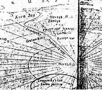
My latest estimate of the location of the North Polar Opening is based on several considerations. There is the case of the Lost Soviet flyers who flew north from Russia and were lost somewhere between the Kara Sea on the Russian side of the pole and Alaska, as reported by Vilhajalmur Stefansson in his book, UNSOLVED MYSTERIES OF THE ARCTIC.
Then there is the Olaf Jansen's story in which he described their 1829 trip through the North Polar Opening in their small boat sailing between leads in the ice on a course heading North East of Franz Josef Land. Recently, in Jan Lamprecht's book, Hollow Planets, he describes the sighting by Peary and Cook and other arctic explorers such as Col. Green of the U.S. Navy of a mirage of land North West of Ellesmere Island in Northern Canada.
Jan also writes of the Russian
sighting of Sannikov land north of Russia. The Amundsen dirigible transpolar
flight of 1926 from Spitzbergen to the Pole and from the Pole to about 100
miles west of Point Barrow, Alaska would indicate the north polar opening
would need to be located to one side of their line of flight. The British
arctic explorer, Wally Herbert, also took this same path only from the other
direction from Alaska to Spitzbergen.
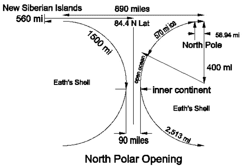
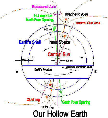
In the above drawing of the North Polar Opening, the thickness of the earth's shell is assumed to be 800 miles. If the earth's shell were any larger, say a thousand or 2,000 miles thick, the polar opening would be too big to be hidden in the Arctic Ocean. So the 800 mile estimate of the earth's shell thickness is a reasonable estimate.
The beginning of the curvature into the opening begins at 890 miles diameter. At the 570 miles from the North Pole which is approximately 1/4 of the way into the opening, we would reach open ocean past the ice. At the center of the polar opening, I am estimating the diameter to be 90 miles.
On above map, the North Geographic Pole would be 58.94 miles within the beginning of the curve into Our Hollow Earth. The distance from the North Geographic Pole and 84.4 degrees N Latitude is 5.6 degrees from the pole, one polar degree = 68.939 miles putting the center of the opening at 386.0584 miles from the North Pole.
This location for the polar opening would be consistent with the lost Soviet Flyers who flew north of the Kara Sea towards Alaska and were lost.
This position is also consistent with the Soviet Ice Breakers that take tourists to the pole each year north of Franz Josef Land.
This estimated location would place the opening on the Russian side of Amundsen's line of flight from the Pole to Alaska, and yet also be in the line of sight of the direction that Admiral Peary sighted the mirage of Crocker land from the west coast of Ellesmere Island in Northern Canada.
Indicative that the curve into the opening has already begun near the pole
is Amundsen's navigator error upon reaching Alaska. They had assumed a
straight line of flight from Spitzbergen to the Pole and from the Pole to
Point Barrow, Alaska, but upon arriving in Alaska were surprised that they
were around a 100 miles too far west of Point Barrow, closer towards the
Bering Sea that they didn't even see Point Barrow. This may indicate that
near the pole they had actually dipped somewhat down into the polar opening
causing their straight line of flight to be skewed.
This encouraged them to continue north. Again, several days
further on, on page 84, Olaf reported, "...we discovered... that we were
sailing slightly north by northeast." If this can be taken as any indication
of the direction they were sailing, the north polar opening would seem to be
located northeast of Franz Josef Land, in the same area that the Soviet
flyers were lost, as described in Vilhajalmur Stefansson's book, UNSOLVED
MYSTERIES OF THE ARCTIC, and in the same direction that Admiral Peary and
Cook saw the mirage of Crocker land from the west coast of
Ellesmere Island.
They found rock and large quantities of mud and driftwood on
some of the icebergs that indicated to Nansen that much of the Arctic ice
originates in some river, perhaps further to the north than they were then
located -- in some uncharted land.
He remarked that it had a hazy, smoky-red color, similar to the
description of the inner sun given by Olaf Jansen, whose father also at
first thought it was a mirage, when they first caught sight of it in their
1829 journey to the inner world through the North Polar Opening northeast of
Franz Josef Land.
Then
volcanic dust fell on the Fram and settled everywhere causing discomfort and
irritation. Nansen wrote in his ship's journal, "Let us go home. What have
we to stay for? Nothing but dust, dust, dust." There must have been volcanic
eruption on the inner continent near the Polar Opening at that time because
there was none on the outer world. The dust must have blown out of the Polar
Opening onto the ice and upon Nansen's ship, the Fram.
Remains of woolly rhino, steppe lions, giant deer, mammoth, foxes and a hardy breed horse that scientists claim are prehistoric are preserved in the Arctic ice. Recently these scientists have been attempting to find some of these exotic animal remains that are frozen and preserved in Arctic ice.
They want to take samples of the frozen flesh and use it to clone these
exotic animals to start a sort of Jurassic Park. Little do they know that a
Jurassic Park already exists located inside Our Hollow Earth, and can be
reached through the North Polar Opening, north of the New Siberian Islands,
from whence all the frozen exotic carcasses come from.
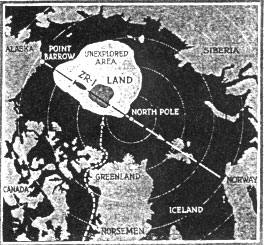
Later, Lt. Green published an
article in
Popular Science Monthly, in the December 1923 issue, that he was still
convinced that Crocker land still existed and had even convinced the Navy to
build a dirigible named the ZR-1 that was going to attempt an over flight of
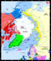
that land. Here is Lt. Green's Arctic map showing his estimated location of
that unknown land that MacMillan and his eskimos thought was just a mirage.
This layer of warmer air above the colder air next to the ice causes mirages or reflections of the ground or ice on the ocean, and not the sky, as in the warmer climates of the world.
In the warmer climates of the world the temperature of the air becomes colder with height above the ground. Just the opposite is the case in the Arctic and Antarctic. Warm, moist air emanating from the earth's hollow interior through the polar openings rises above the ice and serves as a boundary of air that reflects objects on the ground.
Jan Lamprecht, in his book,
Hollow Planets, gives
solid evidence that the mirage of Peary's Crocker land and
Cook's Bradley
land could easily have been a double inverted image of land within the North
Polar Opening located somewhere northwest of Ellesmere Island within the
area Lt. Green termed on his map the "Unexplored Area." Notice that my
estimated location for the North Polar Opening is located within
Green's
unexplored area. The land that Green thought must be there, is, however,
actually located within the Polar Opening.
The Greenland colony, consisting of two settlements on the west coast of Greenland, one further north than the other, thrived for several centuries, but then as Europe became embroiled in war and the disease of the plague, the Norwegians lost contact with their Arctic colonies in Iceland and Greenland. The last ship known to have returned from their Arctic colonies to Norway was in 1410.
When the Dark
Ages had past and Greenland was once again rediscovered with
Hans Egede
establishing the first modern settlement there in 1721, all that could be
found of the original Viking settlers was their ruins and some of their
animals. Even the Arctic author Vilhajalmur Stefansson in his book,
UNSOLVED
MYSTERIES OF THE ARCTIC, concluded that the disappearance of the lost
Viking
colony in Greenland was a mystery. The Viking colonists had apparently
migrated further and further north where they found wild life and fish more
plentiful, until they disappeared.
The Viking explorer parties had come back and had told the rest of their Greenland colony of their wonderful discovery. All promptly packed their bags, and singing songs, departed suddenly northward and never returned. The eskimo tradition is that over the ice towards the northwest, in the direction Admiral Peary sighted Crocker land and Cook sighted Bradley land, is a ...
Lt. Green shows that
trail on his map. It is located on west side of Greenland, and goes up
around Ellesmere Island, and out over the pack ice in a northwest direction
towards the land he claimed exists in the "Unexplored Area." That is the
same area I have estimated the North Polar Opening is located.
Bradley land was also sighted in that same general direction by Polar explorer Dr. Cook on his way to discover the pole. From Alaska, from Harrison Bay, was sighted land also towards the north west by Captain Keenan. If we draw a line from each of these locations towards their respective directions in which anomalous land was sighted, we arrive once again at the location I have determined must be the location of the North Polar Opening centered on 141 E Longitude, 84.4 deg N Latitude.
"click" images to enlarge
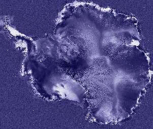
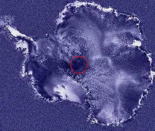
This circular area of low radar reflectivity near the center of the image on this RadarSat image of Antarctica appears to be about 400 miles in diameter.
This location of the South Polar opening is located in the same area that looks like an elliptical area in the Apollo 17 image.
The location for the South Polar Opening is located on the earth opposite the North Polar Opening. The North Polar Opening I have estimated to be located centered on the coordinates of 141 deg E Longitude, 84.4 deg N Latitude.
The location of the South Polar Opening then is located 180
degrees opposite the location of the North Polar Opening, or at 39 deg W
Longitude and at 84.4 deg S Latitude.
|