|

by Robert Bast
from
Survive2012 Website
Contents
1.
General Information
2.
Who created the Lines?
3.
Who were they created for?
4.
Belt of Orion?
5.
Other Geoglyphs
General Information
Introduction
The world is full of mysterious places that have outlived the
history of their construction. These are the pyramids, citadels,
stone circles and statues that are much written about and are
visited by hordes of tourists.
One quality that makes humans unique is their ability to create and
appreciate works of art. Determining which ancient sites are art,
and which are something more, is a tough call to make. Therefore,
for the purposes of this book, I have set three requirements that
can help us make such a decision. If the purpose of a site is to
inform us about a cyclical global catastrophe, it must:
1. Be able to survive long
periods of time
Whether the period between catastrophes is 1,000 or 100,000
years, the site must be able to endure the extremes of weather
and human interaction. I doubt that any structure built today is
designed to last even one millennium, and there is a reason for
that – they don’t need to. Yet, globally there are sites that
have outlasted the very cultures that built them – often of such
gigantic dimensions it would be difficult to recreate them
today.
2. Use the universal languages of numbers or symbols
Written languages are impossible to rely on, for they keep
on changing. Not only are they affected by the latest fads and
fashions, they can disappear altogether due to the assimilations
and annihilations that are caused by cultural conflict. Just
look at today’s near extinction of the Gaelic language, and how
difficult it is to read Shakespeare’s “English” today. Languages
will always change, whereas mathematics is a universal constant.
A building four times as long as it is wide will always
represent a ratio of 4:1, no matter how old it gets, or who
studies it. Symbols are not perfect, but are still far more
stable than words. Especially so if they resemble a
constellation, an animal, a shape and so on. Hieroglyphs that
use indirect representations are more difficult to decipher, yet
most of them have eventually been decoded.
3. Contain coded information concerning the nature of such a
catastrophe
This is the hardest aspect to determine. A good example is
the Great Pyramid of Giza. We have always known of its
antiquity, and in the last century we have become aware of the
mathematics contained within its dimensions. But is it trying to
tell us something? Theories abound and can become overwhelming.
Therefore I have chosen to concentrate on a single, succinct
idea, the cyclical global catastrophe, and apply it to not only
the Giza complex, but every ancient site I study.
The Nazca lines conform to these three
rules. They are at least 1500 years old, and are capable of lasting
very much longer than that. That they embody symbols is obvious, and
it is my belief that they describe the Great Flood.
General
Information
The Nazca lines and figures cover a total area of 520 square
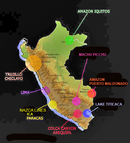
kilometers.[1] They are situated 400 kilometers south of Lima on the
Pampa Colorada - a desolate plain between the Peruvian coast and the
Andes Mountains (see map below). It is a rocky desert, rather than a
sandy one. Its surface is covered in small stones that are dark red
because they contain ferrous oxide. These have been cleared away to
expose the lighter-coloured soil underneath, creating a multitude of
lines.

Dozens of stylized figures have also
been etched onto the desert, creating the world’s largest piece of
art. The figures have each been drawn using a singular continuous
line, with the largest being some 285 meters long. There are 70
figures in total. In the most part they are creatures, such as a
hummingbird, llama or dog - however a flower, loom and geometric
shapes can also be seen.
It has been mentioned by other researchers that many of the
creatures represented are not native to the area. The most striking
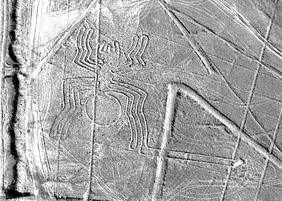
example of this is the 45 meter long Spider. It was identified as a
member of the rare genus Ricinulei, which is only found in the most
remote and inaccessible parts of the Amazon Jungle. These spiders
are only 5-10 mm in length. One leg is noticeably longer – it is a protrusible tube, and at its tip is the spider’s reproductive organ,
normally only visible with the aid of a microscope.[2]

 
This information appears to signify an
advanced ancient culture at work, but fails when inspected more
closely. The only similarity between the spider figure and a Ricinulei is the extended leg. Otherwise the figure could be just a
common local spider. Or the same as the depiction found at the
Etowah Mounds (USA). Many of the figures on the plain have an extra
leg or pathway attached to them – all we have here is a coincidental
stylization.
 Overlaying
the figures are 800 straight lines, some stretching far away, over
hills and into the distance. The longest attain a length of eight
kilometers, with one being an incredible 65 kilometers long! The
lines were formed on top of the drawings and cut right through them.
This suggests that they were created at a later date, unless of
course this effect was done deliberately. Overlaying
the figures are 800 straight lines, some stretching far away, over
hills and into the distance. The longest attain a length of eight
kilometers, with one being an incredible 65 kilometers long! The
lines were formed on top of the drawings and cut right through them.
This suggests that they were created at a later date, unless of
course this effect was done deliberately.
Pilots first noticed them in the 1920s. In 1941 Dr Paul Kosok from
the Long Island University was dispatched to survey them. Once
there, he found the faint outline of a bird – the first animal
figure to be discovered. He also realized that most of the lines
fanned out from “radiating centers”, and decided that they described
astronomical information. To survey Nazca properly would take many
years, and he was too busy on other projects to do it himself. He
found his replacement in a German woman who was translating an
academic paper into Spanish for him. Maria Reiche had shifted to
Peru in 1932 to work as a private teacher, but before long she was
teaching languages and translating. Initially Reiche made short
visits to the lines from her home in Lima. But as time went by, and
she became more and more dedicated to solving the enigma, she moved
closer to the lines – shifting from a Nazca hotel to a ranch that
was within walking distance of the lines. After a decade on the
ranch, she decided to live on-site, eventually dedicating her
remaining 50 years to studying the patterns and working toward a
solution.

It was Reiche who discovered the other
animal figures. None of these were observable from the air until she
had carefully cleaned away the dust of centuries that obscured them.
She agreed with Kosok that their meaning was derived from astronomy,
and was unable to consider other possibilities. She privately
published a book on the subject, but failed to conclusively prove
her theories.
 
Apart from the multitude of straight
lines, Maria found triangles, “needle and thread” patterns,
trapezoids, a labyrinth and spirals. There are more than a hundred
spirals. Near the centre of one she found a stone engraved with a
serpent design and a severed head – prompting her to believe that
every spiral at Nazca represented a serpent. The image below is from
a textile that was wrapped around a mummy found near Nazca.

Her contribution was more than just
highlighting the lines’ presence – she protected them as well. Human
feet and
vehicles can easily ruin the lines.
Right up until her death at 95, Reiche almost single-handedly saved
the lines from being ruined by trespassers, even known to chase them
away in her wheelchair. Thanks to her efforts, which also kept
governments and private enterprise at bay, the lines have now been
declared a ''world
cultural heritage site'' by UNESCO.
Because of their huge size, the only way to appreciate the lines and
images is from the air, which automatically poses the question: Did
ancient cultures have a means of flying? Authors such as Erich von Däniken latched onto this idea, and have used this site as the
cornerstone of their
Ancient Astronaut hypothesis, ignoring any
non-UFO explanations.[*]
There are other questions we can ask that are more productive in our
search for a solution...
Go Back
[*] Whether or not UFO’s exist is
outside the scope of this book.
[1] The Marshall Travel Atlas of Mysterious Places, Marshall
Editions, 1977, p98
[2] The Marshall Travel Atlas of Mysterious Places, Marshall
Editions, 1977, p98, first determined by Hawkins, Beyond
Stonehenge, Arrow Books, London, 1977
|


 Overlaying
the figures are 800 straight lines, some stretching far away, over
hills and into the distance. The longest attain a length of eight
kilometers, with one being an incredible 65 kilometers long! The
lines were formed on top of the drawings and cut right through them.
This suggests that they were created at a later date, unless of
course this effect was done deliberately.


