|

How does a hurricane “work?”
In traditional meteorological theory, it is hot westward blowing
winds coming off the Sahara Desert in northern Africa – after being
“uplifted” over the mountains lying in Ethiopia - that subsequently
flow out over the Atlas Mountains in Northern Morocco… and out over
the warm, moist equatorial waters west of the “Dark Continent,”
as a series of turbulent eddies and unstable atmospheric waves
(below).
These unstable air currents subsequently spawn massive thunderstorms
over the warm ocean waters west of Africa ... which,
if conditions are just right, fuel the creation of a “tropical
depression.”

“Tropical depressions” form low pressure centers and begin to rotate
slowly around these centers for two reasons:
1) the energetic
convective activity (rising and falling air) in the vigorous
tropical thunderstorms west of Africa creates a region of lower
atmospheric pressure ... which outside air rushes in to try to
equalize
2) that inward rushing air inevitably spins faster as it
approaches the low pressure center, due to so-called “Coriolis
forces” (caused by the rotation of the Earth itself --
below)
This
is coupled with another physical effect called “conservation of
angular momentum” (the same phenomenon exhibited by skaters when
they pull in their arms, and thus spin faster) – the tighter the
winds swirl around the center, the faster they must spin ....

This warm, upwardly rising ocean air leaves below it a region of
increasingly low pressure … which more in rushing ocean air attempts
to equalize. As the original water vapor-laden air rises higher, it
also gets cooler … and eventually the moisture it contains condenses
out and falls as massive rain. In the process of condensing, this
rain releases “latent heat” into the surrounding air, heating it
even more, so it rises faster, and more outside air has to rush in
below to equalize the even more rapidly decreasing pressure. This,
in turn, accelerates the inward spin and upward motion of the
rotating mass of air as more rising moisture condenses, releasing
more rainfall ... which releases more latent heat, etc., etc., etc.
….
This highly interrelated process – rising winds … buoyant air …
lower surface pressure -- rapidly becomes self-reinforcing …
resulting in the by now unfortunately all-too-familiar picture
(below)!

Eventually, the spin rate of this “organized,” moisture-laden air
exceeds 39 mph (I wonder who picked THAT intriguing “magic” number
…) and our unnamed “tropical depression” officially becomes a named
“tropical storm.”
As this convective/spinning “positive feedback loop” continues,
eventually the wind speeds around the circumference of the center
“eye” - composed of monstrously towering thunderstorms and
constantly condensing water - exceeds 74 miles per hour
(below)
… and our “tropical storm” at this point is officially
declared a full-fledged hurricane.
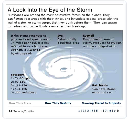
The “Category” into which a hurricane is placed by the
National
Hurricane Center is rated according to the rotating sustained winds
around the central “eye”
(above).
“Category 5” is the maximum wind rating on the current “Saffir-Simpson”
scale -- although Hurricane Andrew was reported to
have come ashore with sustained winds of over 200 miles per hour …
before the anemometers at Homestead Air Force Base were
destroyed.

Again, in conventional meteorological theory, since this immense
power ultimately comes from warm, evaporating ocean water … once the
storm hits (literally) “dry land,” it is deprived of its primary
energy source and must inevitably wind down … but not before doing
incalculable damage to lives and property ashore ….
So, where does our
Hyperdimensional Model come into play in this
scenario? Hyperdimensional Physics is essentially a physics of rotation.
In a Category 5 hurricane, a massive amount of air and water is
being rotated at high velocity around a circumference ranging from a
few hundred miles (for the highest Category 5 sustained winds around
the “eyewall”), to over a thousand miles (the circumference in a
Category 5 storm where the winds fall below a Category 1).
This is a volume (if the storm’s height is modeled as a flattened
donut, stretching up to over 40,000 feet –
below)
totaling approximately two million cubic miles (!) of howling wind
and water ….

In the Hyperdimensional Model, rotating masses act differently than
masses which are not rotating; and this is especially true when
their interactions take place in a gravitational field. These major
dynamic anomalies - which completely contradict both Newtonian
Mechanics and Einstein’s Relativity - have been confirmed in a
series of
remarkable laboratory experiments carried out over 30
years ago by the late physicist, Dr. Bruce DePalma.
The most classic of these, dubbed “DePalma’s Spinning Ball
Experiment,” involved the simultaneous ejection, via an angled
spring mechanism, of two steel “pinballs” – one non-rotating, and
one spinning at ~27,000 rpm
(below). As
DePalma himself described
it:
“Basically, the spinning object going higher than the identical
non-rotating control, with the same initial velocity, and then
falling faster than the identical non-rotating control, presents a
dilemma which can only be resolved or understood on the basis of
radically new concepts in physics -- concepts so radical that only
the heretofore not-understood results of other experiments (the
elastic collision of a rotating and an identical non-rotating
object, et al.), and new conceptions of physics growing out of the
many discussions and correspondence pertaining to rotation, inertia,
gravity, and motion in general [can explain this effect]….”

Leaving aside, for the moment, the theoretical explanations for
DePalma’s astonishing experimental results, it can be seen on the
graph that the spinning mass flies higher, faster... and falls
farther, faster … than the non-spinning mass. As DePalma noted -
this completely violates the “normal” rules of all the physics we’ve
been taught!
Again, this is not “theory”... this is the result of careful,
repeated laboratory experiments - carried out by a world-class
physicist from MIT and Harvard ….
So, how does this apply to spinning hurricanes?
As we have shown, the standard model for the enormous, rotating
“engine” of a hurricane says that it is initiated by heated, rising
air. This air, in turn, is lifted by its “hot air balloon-like”
buoyancy against the force of gravity (the red “convective towers” –
below right).
But, what if “heat” wasn’t the only way to lift that air? What if
another “force” could intervene after the warm air was already
rotating and rising … and resulted in the same accelerated upward
motion of the rotating mass of air and water in the hurricane as DePalma repeatedly measured in his “spinning ball” laboratory data
…?

If DePalma’s startling results are accurate, and “spinning masses”
in fact rise higher (for a given upward force, and in the same
gravitational field) compared to non-spinning masses - then in a
vast, spinning hurricane - with horizontal howling winds
approaching 200 miles per hour circling the “eye” – there should be
a small but measurable additional upwardly directed force assisting
the already present warm air “buoyancy effect.”
The higher the Category storm, the larger this “assisting force”
should be … until, at some point on the Saffir-Simpson Scale, the
added buoyancy from this mysterious “spin energy” approaches that
same level of "lifting force" being liberated by the latent heat
from the water condensation in the hurricane….
It is at that point – apparently at Category 5 – that a remarkable
geometric control of this accelerated, rising air could become
visible against the normal “entropic” background thermal motions of
the storm … resulting in the remarkably geometric “eye” that
NOAA
photographed in Isabel, in 2003
(below).
It is this stunning “eye geometry,” impressed on the highly visible
atmospheric “tracer” -- the condensing clouds of water vapor in the
very center of the storm – which confirms, like the impossibly
regular geometry also seen around Jupiter’s and Saturn’s poles, that
this can only be a hyperdimensional phenomenon….

Parts
1 |
2 |
3 |
4
Go Back
|